Fiji: the Lau Islands on the right.

If checking out from Suva.
The necessary cruising permit to visit the islands is issued, on request, at the iTAUKEI AFFAIRS BOARD (Indigenous Affairs Board – TAB) office at 87 Queen Elizabeth Drive, Government Buildings, Suva, or at the the Commissioner Western’s office in Lautoka, the Commissioner Eastern’s office in Levuka, or the Provincial Office in Savusavu.
Permits are issued promptly, often “while you wait”, or can be obtained via a marina, which normally takes 3 working days. If obtained via a marina there is normally an administrative charge of $5-10 for this service.
Cruising Permits are issued free of charge for all areas of Fiji and now automatically include the Lau Group.

A southern option. From Suva to Matuku Island. 100 nm @ 128˚ (likely upwind)

Matuku
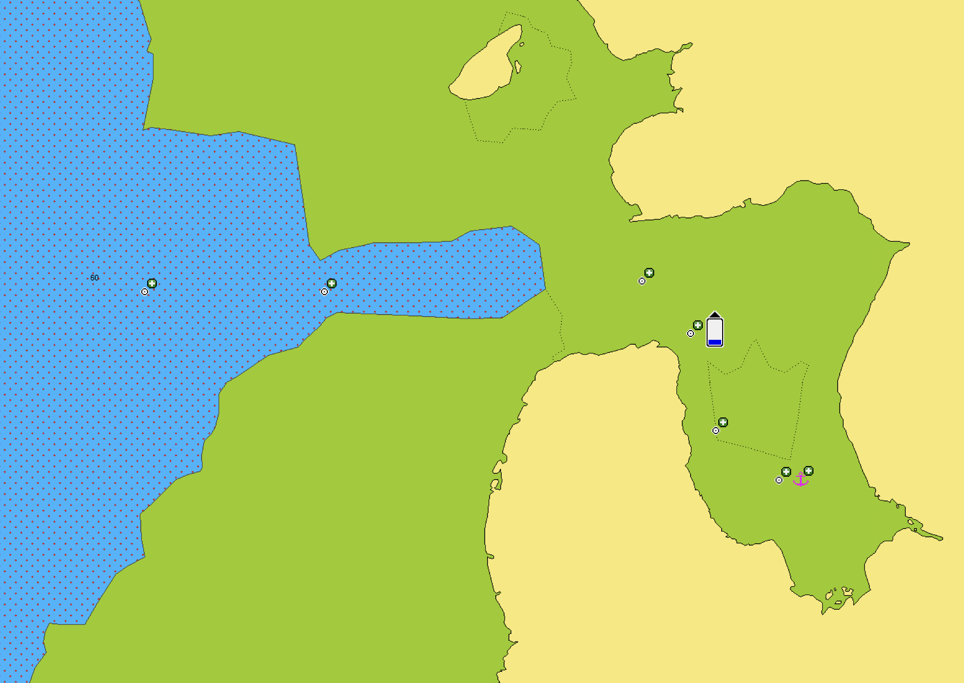
This is a beautiful, verdant, high volcanic island, with its crater open to the west through a wide, clear pass. There is an excellent sheltered anchorage, 10 – 15m over mud inside the crater off the village of Lomati. Other deeper, less sheltered anchorages are in the channel inside the pass, to the north of the main channel (17m over sand), or south of the main channel, amongst coral (6m over sand). There are more marginal anchorages inside some narrow passes on other coasts.

Matuku Harbour
Seven villages are spread around the coasts, with total population about 800. No airport, only occasional shipping and yachts (mostly surf and dive charters). The main village is Yaroi, on the NW coast, with a clinic and school. Anchorage is possible off another delightful village, Makadru, south of the pass.
Source here.

From Matuku Island to Vulaga Island. 100 nm @ 88˚

It would also be possible to break the trip with stop-offs at Totoya Island and/or Kabara Island.
Totoya. Wikipedia

This very unique horse-shoe shaped island has a lagoon within a lagoon. The island is an ancient volcano and the creator has sunk leaving a nearly land-locked inner lagoon.
There are 2 big well charted passes through the outer reef one in the north and the other in the West. Several good anchorages are available the best in the outer lagoon is on the west side Niavaka Gap. Alternatively yachts can then make their way round into Totoya Bay (the inner Lagoon) in the center of the horse shoe. This bay provides a deep water anchorage and protection from all wind directions.
The Chiefly village of Tovo should be visited first to present your gift of Kava to the high chief. The island
offers some great exploring and has many unspoiled and untouched white sandy beaches. There is good diving in the many small passes through the outer reefs.

Tovu village

Totoya Island
Fulaga (Vulaga)

Vulaga consists of an oval rim of jungle-covered hills of raised coral, around a lagoon about 6 miles by 5 miles where the small sailing canoes (Waka) are still seen today.
There is one 50m-wide pass into the lagoon, straight but challenging – and dangerous in bad weather or strong tides. Inside the lagoon are countless mushroom islets and some larger islands dotted with rare palms, countless anchorages over white sand, usually <10m deep. At least one anchorage could be considered hurricane shelter for a small boat.
The pass is difficult, but can accommodate at least a 35m vessel with a draft of 3m. This cannot be attempted with a strong current running and the usual time to enter this pass is on slack water, which is usually at half tide.
'Be aware that Vulaga is like an atoll with a narrow pass. You need to enter at slack tide, and high tide is preferable. Thus you’ll want to time your arrival carefully, arriving early enough to sit and watch the entrance while ready to motor in as soon as the water calms down.' Source.


Vulaga Pass
Population is about 400 over three villages. One village (Naivindamu) lies on the W shore inside the lagoon, with good anchorage about 200m offshore allowing ready contact with the welcoming villagers. The other two villages lie close together on the southern edge, with two tracks leading from the lagoon to them. The head village, Monacake, where one should present the sevusevu, has the school and clinic, and is about half an hour’s easy walk over the hills. No airport, and very infrequent ships make this a very isolated world, rarely visited by yachts but well worth the trip.


No comments:
Post a Comment